More than two dozen people had their questions answered about the Bradford Bypass at a second Public Information Centre (PIC), but how much the highway will cost or when it will be completed remain up in the air.
Despite being purposely vague in their answers at times, representatives from the Ontario Ministry of Transportation (MTO) and AECOM gave a detailed overview of the project during the PIC on Nov. 24.
The total cost of the 16.9 km highway won’t be released at this time to help maintain the integrity of the project and protect taxpayers, explained Wan Chi Ma, senior project manager for MTO.
“As we bring the project to the market, we really want to ensure that we can retain the best value of the project,” Ma said. “Therefore, we are not able to release the cost estimate prior to the award of the contract. The reason we do this is to protect the procurement process.”
Ma noted the Province of Ontario is committed to “fully funding the construction of the Bradford Bypass.”
Her colleague, Project Manager Alex MacLean told the attendees on the virtual call only that the final Environmental Impact Assessment Report will be completed in 2023. Further public consultation will be provided during that report’s draft stages, anticipated for early in the year.
Included in that draft report will be the preferred route of the bypass, currently planned to be a four-lane controlled access freeway between Highway 400 in Bradford West Gwillimbury and Highway 404 in East Gwillimbury. Enough of a right-of-way will be secured to ensure the highway can be widened to accommodate eight total lanes of traffic through the corridor, including three lanes of regular traffic and one high occupancy vehicle lane in each direction.
There have already been adjustments made to the route based on consultation with various stakeholders, including Indigenous communities. The approved route in the 2002 Environmental Assessment (EA) saw the highway travelling west in more-or-less a straight line between Sideroad 10 and County Road 4. The new preferred route will see the highway arc to the north with radii curves of 1,700m and 1,300m between Langford Boulevard and County Road 4.
“A large lake woodland site, known as the Bradford Hill site, was encountered in 2020 and it was subject to Phase 3 excavation as well, over 2021/2022 field seasons,” said Riyaz Sheikh, deputy project manager for AECOM. “Considering the sensitivity and importance of this site to Indigenous nations, the avoidance of this site was deemed a priority.”
The PIC also revealed the preferred alignments for the interchanges along the route, at, County Road 4, Bathurst Street, Second Concession and Leslie Street along with the terminal interchanges at Highway 404 and Highway 400.
Four other roads - Line 9, Professor Day Drive, Artesian Industrial Parkway and Yonge Street (near River Drive Park) - will cross the highway without an interchange, although right-of-way exists at Professor Day Drive if one is warranted in the future.
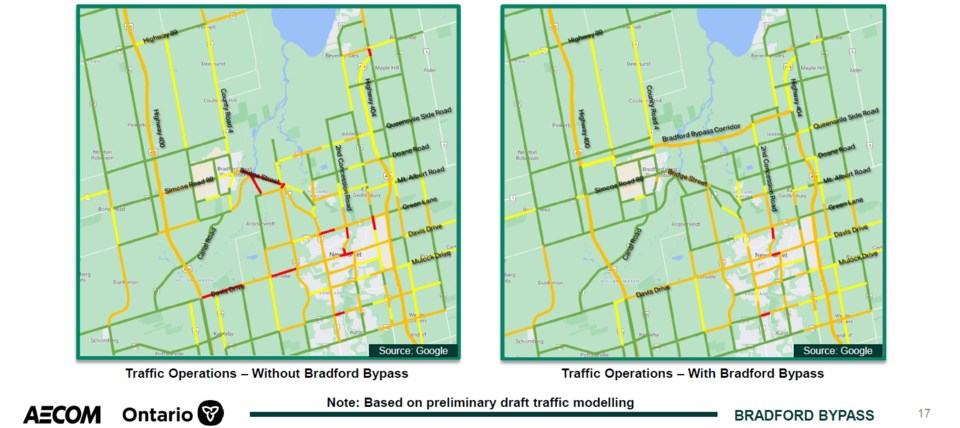
Proponents of the Bradford Bypass argue it will be a game changer when it comes to moving people through Bradford West Gwillimbury and East Gwillimbury, with developments already springing up in anticipation of its completion, such as the new Loblaws distribution centre between Sharon and Queensville.
Even as investments are made to mass transit in the region, road congestion will continue to increase unless the bypass is constructed, participants were told. The bypass, it was argued, is the best way to curb that congestion.
“A major freeway connection, the Bradford Bypass will also help goods to go faster, people be able to travel faster within the (Greater Toronto Area)… boosting the Ontario and Canadian economy,” Ma said. “Another thing we will see is time-saving. Motorists and trucks are anticipated to see significant saving in travel time - when using the Bradford Bypass compared to the existing local routes – of approximately 35 minutes.”
Many of the questions asked dealt with environmental concerns, including salt run-off during the winter, air quality and noise concerns and how the route travels through the Holland Marsh. How the project could be completed without compromising the environment was at top of mind for several people taking part in the PIC.
Within the route, there are 12 designated natural areas, 13 species at risk and 18 species of conservation concern, with about 133 hectares of vegetation slated for removal. The province hopes to mitigate some of the environmental impacts through design refinements and ecological restoration and landscaping plans, all to be developed as the process continues.
A wildlife crossing is also proposed to be included under the highway between Second Concession and Leslie Street, with other opportunities to be built near the Holland River and Holland River East Branch.
“This government takes environmental protections very seriously and will ensure environmental protections are not compromised when building this infrastructure,” said Rhonda Gribbon, environmental planner with the MTO, who also referred to the original approval provided in 2002 for the route, that saw comparisons between 10 alternative corridors and 43 associated routes.
“The EA process demonstrated how the advantages and disadvantages of each alternative in terms of their impacts on the environment were measured and assessed to determine the route that we’re going forward with now,” she said. “The Ministry is still required to complete additional environmental studies as noted and document consultation during each phase, as well as obtain any permits and approvals, federal and provincial.”
The MTO and AECOM are accepting comments on the material presented at the PIC until Dec. 8, 2022. Visit https://www.bradfordbypass.ca/pic/ to view the materials and submit your feedback.


