Before there were roads through West Gwillimbury, there was water. First Nations and fur traders used the east and west branches of the Holland River to reach Lake Simcoe, and they followed an overland trail — known as the Carrying Place — to travel the 43.5 kilometres to Toronto.
Lt.-Gov. John Graves Simcoe followed the route in 1793, when he camped near the north branch of the Holland River (Fraser Creek), and founded Fort Pine. Concerned about vulnerability to American attack, if Upper Canada relied only on the Great Lakes to transport goods and troops, Simcoe explored overland and inland water routes. On his way back to York, which he had established as the new capital of Upper Canada, he was shown a route that utilized the east Holland River, and avoided the Holland Marsh.
Yonge Street had initially been surveyed by Samuel Holland as a land route linking Lake Ontario with the Holland River — a navigable route to Lake aux Claies (renamed Lake Simcoe by the Lieutenant Governor in honour of his father) and to the north. Construction of the road had stalled until Simcoe set his Queen’s Rangers to work in 1795, constructing what he named Yonge Street, south from St. Albans (Holland Landing).
There was still no direct route to Bradford and West Gwillimbury, except by walking through two miles of swamp and using a primitive ferry, or waiting until winter when the frozen surface made the marsh passable. Settlers in the early 1800s petitioned parliament for a bridge and improved roadway, to connect them with Yonge Street, and, in 1824, Parliament set aside 150 pounds “to aid the inhabitants of West Gwillimbury and Tecumseth in building a bridge across the West Branch of the Holland River.” In that year, Robert Armstrong built a so-called corduroy road — made of cedar logs or tamarack poles — from Bradford to Holland Landing, and a floating bridge over the river.
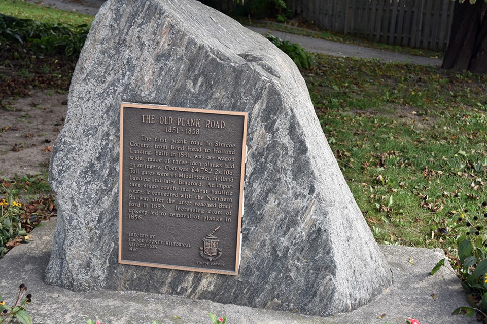
The corduroy road was replaced in 1851 by the Plank Road, built by the County of Simcoe and stretching from Bond Head to Holland Landing. Built of nearly one-metre-long planks, it was not cheap. The cost was nearly 4,800 pounds sterling, and to help pay for the road and its maintenance, toll gates were set up at Middleton, Bradford and Holland Landing. The Plank Road was an important route for travel, and commerce — especially once the Northern Railway reached Bradford in 1853. But the cost of replacing the planks became prohibitive, and, in 1858, they were removed. The road reverted to clay and gravel, posing a challenge in springtime and whenever it rained. The route became County Road 88 in 1938, but was not paved until 1957.
The floating bridge survived until 1862, when a sawmill owner cut it in two places because it interfered with the logs floating to his mill on the east bank of the Holland River. The bridge was repaired, and, in 1872, replaced with a wooden structure that allowed commerce to pass underneath. In 1908, a steel span, with wooden plank floor, was built across the river — in 1930, a new concrete bridge.
Sources: Governor Simcoe Slept Here: The Legacy of West Gwillimbury, Bradford West Gwillimbury Public Library archives, and other online sources.
Do you know an interesting story about BWG's history? Contact [email protected].


